Colca Canyon and the Condor Flight: Peru's Great Gorge
Twice as deep as the Grand Canyon in places, Colca is one of the world's deepest gorges and the place where Andean condors — among the largest flying birds on Earth — can be watched from a few metres, riding the thermals at eye level.
At the Cruz del Cóndor viewpoint, on the lip of the Colca Canyon in the southern Peruvian Andes, you wait in the cold of the early morning — often at seven or eight degrees Celsius despite being at 3,710 metres in the sun — and then the birds appear. Not from a great distance, as raptors tend to do in other landscapes, but from directly below: the condors launch from their roosting ledges in the canyon walls and rise on the morning thermals past the viewpoint at astonishing proximity, close enough to read the pattern of the feathers on the inner wing surface, close enough to see the bare pinkish skin of the head and the white ruff of neck feathers, close enough to feel a faint displacement of air as they bank and turn. Andean condors (Vultur gryphus) have a wingspan that can reach 3.3 metres — the largest of any land bird in the world — and at that range the physical fact of them is simply extraordinary.
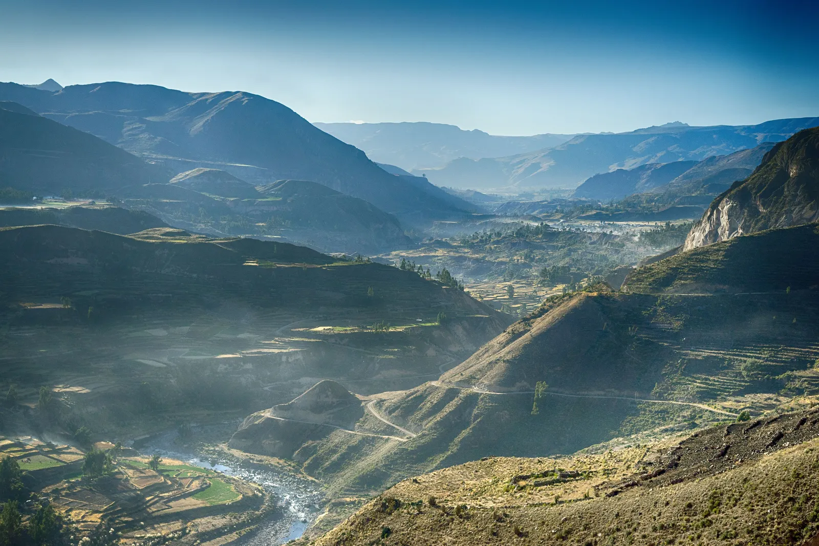
Colca Canyon itself is an achievement of geography before it is a wildlife spectacle. Its maximum depth, near the village of Cabanaconde, reaches approximately 3,270 metres below the canyon rim — making it one of the deepest canyons on Earth, significantly deeper than the Grand Canyon of Colorado. The river that carved it, the Río Colca, descends from the high altiplano south of Arequipa through agricultural terraces that were built by the Collagua and Cabana peoples before the Inca conquest and are still actively farmed today. The canyon is not a wilderness in isolation; it is a working Andean landscape, with villages, churches, hot springs and one of the most sustained concentrations of pre-Columbian agricultural terracing in the Americas.
The canyon: geology and scale
The Colca Canyon was formed by the Río Colca cutting progressively deeper into the volcanic plateau that underlies the southern Andes — a plateau whose surface was originally deposited by the eruption of the many volcanoes that rim the region. The canyon walls expose the geological history of this uplift in section: volcanic tufa and ignimbrite near the top, older sedimentary layers below, with the canyon floor following the ancient basement rock at depths that are difficult to comprehend from the rim. The maximum depth figure — approximately 3,270 metres at the deepest measured point — refers to the distance from the canyon rim near Cabanaconde to the river surface far below, a drop for which even photographs taken with the longest telephoto lenses give an inadequate sense.
What makes the canyon topographically unusual is the combination of its depth with the agricultural landscape above it. The rim of Colca is not a desert edge but a fertile, terraced zone at around 3,500 metres elevation, studded with villages whose colonial churches were built on the foundations of pre-Inca structures, their towers visible for kilometres across the plateau. The contrast between the orderly geometry of the terraces — some of them still irrigated by the same pre-Columbian water systems that the Collagua people built — and the brutal abyss immediately below them is one of the defining visual experiences of the canyon.
The condors: biology and the morning flight
The Andean condor is a New World vulture — not related to the Old World vultures despite superficial resemblance, but occupying a similar ecological niche as a large, soaring carrion feeder. Adults have a wingspan of 2.7 to 3.3 metres and weigh between 7 and 14 kilograms; the males are distinguished from females by the prominent caruncle (a fleshy protuberance) on the top of the beak. They are long-lived birds — individuals in the wild can exceed 70 years of age — and slow to reproduce, raising a single chick every other year at most. This reproductive rate, combined with habitat loss and historical persecution (they were shot as threats to livestock throughout much of their range), makes the species vulnerable, though populations in the Colca region remain relatively healthy by the standards of the rest of its range.
The morning thermal flight is the condors' method of beginning their day's foraging range. Condors cannot sustain flapping flight for long — they are built for soaring, not powered flight — and they depend on rising columns of warm air (thermals) and ridge lift to gain altitude before dispersing over enormous distances to search for carrion. At Cruz del Cóndor, the canyon geometry produces reliable thermals from about 8 to 10 in the morning as the east-facing walls heat in the sun, and the condors that roost in the canyon walls below rise on these thermals past the viewpoint with clockwork consistency in fair weather. On a good morning, ten to twenty birds may be visible simultaneously.
The valley and the villages
The Colca Valley — the broader agricultural zone above the canyon — is as much the destination as the canyon itself. The road from Arequipa enters the valley past the Reserva Nacional Salinas y Aguada Blanca, a high-altitude wetland at over 4,300 metres on the rim of the altiplano that holds large populations of flamingos (three species: Andean, James's and Chilean), vicuñas, and various waterbirds. This is often a traveller's first encounter with the high Andes above 4,000 metres, and the combination of the cold, thin air, the extraordinary light and the sight of flamingos in the foreground of snow-dusted volcanoes constitutes an immediate reorientation of the senses.
The valley villages — Chivay, the main service town; Yanque, with its spectacular baroque church; Maca; Lari; Cabanaconde — are inhabited primarily by communities of Collagua and Cabana descent, and the traditional textiles, headdresses and festivals of these groups are among the most distinctive in the Peruvian Andes. The women of certain communities, particularly around Chivay and Yanque, still wear the elaborate embroidered headdress called the montera on ceremonial occasions — a flamboyant flat-topped hat of white with coloured embroidery that is specific to particular communities and can be read as a marker of village identity. The hot springs at La Calera, a short distance from Chivay, provide a therapeutic end to a day's hiking.
Trekking into the canyon
The Cruz del Cóndor is the most-visited point of the canyon, but the most rewarding physical engagement with Colca is to descend into it. The standard two-day trek descends from the Cabanaconde road head on the canyon's south rim to the village of San Juan de Chuccho on the canyon floor, then continues to the oasis village of Sangalle — a green pocket of palm trees and small swimming pools in the depths of the canyon at around 2,150 metres, dramatically warmer than the rim — before climbing back out on the second day. The descent is steep and sustained, losing more than 1,200 metres of altitude on a dusty mule trail; the ascent on day two is correspondingly demanding and is best begun before dawn to avoid the heat of the canyon floor in the middle of the day.
For those with more time and experience, the canyon offers extended routes — connecting villages across the canyon floor, traversing to the opposite rim, following the river downstream toward its confluence with the Majes — that are considerably more committing than the standard Sangalle circuit and require good navigation, sufficient water-carrying capacity and willingness to camp. The canyon floor in its deeper sections is practically tropical in temperature and ecology, a contrast with the altiplano rim of almost theatrical drama. Our guides have walked many of these routes and can advise on the options that best match the fitness and experience of each traveller.
Arequipa: the white city at the canyon's gate
The Colca Canyon is almost always approached from Arequipa, and Arequipa itself deserves more time than most itineraries give it. Known as 'La Ciudad Blanca' — the White City — for its remarkable colonial architecture built predominantly of sillar, a white volcanic stone quarried from the surrounding lava fields, it holds a historic centre that has been a UNESCO World Heritage Site since 2000 and is, block for block, one of the most beautiful Spanish colonial urban environments in the Americas. The convent of Santa Catalina — a walled religious city within the city, a maze of cobbled lanes, painted courtyards and cells that housed cloistered nuns for four centuries — is the single most extraordinary architectural complex in Peru outside Cusco and Machu Picchu.
Arequipa sits at 2,335 metres, framed by three volcanoes: El Misti (5,822 metres), a perfectly conical, occasionally active peak that dominates the city's eastern horizon; Chachani (6,057 metres) to the north; and Pichu Pichu (5,664 metres) to the east. The food scene of Arequipa is one of the most celebrated regional cuisines in Peru — rocoto relleno (a spicy stuffed pepper), adobo (pork braised in chicha de jora and spices), and cuy chactado (crispy guinea pig) are the canonical dishes — and the covered market of San Camilo is one of the most atmospheric markets in the country. Arequipa rewards two nights before the canyon journey north.
Practical matters: getting there and when to visit
The Colca Canyon is 160 kilometres from Arequipa by road, a journey of three to four hours depending on the route taken. Most travellers arrive the afternoon before they intend to visit Cruz del Cóndor, staying overnight in Chivay or one of the smaller canyon villages; the condor flight is a morning phenomenon and the two-to-three-hour predawn drive from Arequipa is possible but tiring. The road crosses the Patapampa Pass at 4,910 metres — one of the higher paved passes in South America — where the combination of altitude and the view of the flamingo lagoons on the altiplano makes a stop both medically sensible and visually rewarding.
The best conditions for condor watching are between April and November, in the dry season, when thermals are more reliable and clouds less likely to obscure the flight. The rainy season (December to March) does not preclude visits — the canyon is green and dramatically misted in this period — but condor sightings are less consistent and the trekking trails on the canyon walls become muddy and sometimes hazardous. Acclimatisation is a genuine consideration: the canyon rim is above 3,500 metres, the Patapampa pass on the approach road is close to 5,000 metres, and travellers arriving from sea level should spend at least a day in Arequipa at 2,335 metres before continuing. The combination of Arequipa (two nights), Colca Valley (two nights) and the condor flight is among the most rewarding four-day itineraries in the Peruvian Andes.
Quick answers
Is seeing condors at Cruz del Cóndor guaranteed?
Nothing in wildlife watching is guaranteed, but the Cruz del Cóndor viewpoint on a fair dry-season morning delivers reliable condor sightings — the canyon geometry and the consistency of the thermals make it one of the most dependable large-bird encounters in the world. Sightings are less reliable in cloudy or rainy weather and in the afternoon, when the thermals have dissipated. Arriving at the viewpoint by about 8am and staying until 10am covers the period of highest activity. Most visitors on organised tours see multiple birds on most days.
How deep is Colca Canyon, and is it really deeper than the Grand Canyon?
The deepest measured point of Colca Canyon, near Cabanaconde, is approximately 3,270 metres from the canyon rim to the river surface — roughly twice the maximum depth of the Grand Canyon (around 1,600 metres). The comparison is sometimes complicated by the fact that the nearby Cotahuasi Canyon in the same region claims an even greater depth of around 3,535 metres, making both Peruvian canyons among the deepest in the world by standard measurement. The Grand Canyon is broader, more visited and more famous, but in sheer vertical dimension it is outclassed by its Peruvian counterparts.
How does altitude affect a visit to the Colca Canyon?
The canyon rim and the approach road are both above 3,500 metres, and the Patapampa Pass on the main Arequipa road reaches nearly 4,900 metres. Arequipa itself is at 2,335 metres. Anyone arriving by air from sea level should spend at least one full day in Arequipa acclimatising before continuing to the canyon. Symptoms of altitude sickness — headache, fatigue, nausea — should be taken seriously. The canyon floor, paradoxically, is lower (around 2,150 metres at Sangalle) and warmer than the rim; descending into the canyon actually improves altitude symptoms for most people.
Is the two-day Colca canyon trek suitable for all fitness levels?
The descent is manageable for most reasonably fit travellers; the ascent on day two is demanding and requires a good level of fitness and strong knees. The altitude on the rim adds significant extra exertion to what would be a moderate-grade trail at sea level. Travellers with knee problems, significant altitude sensitivity or limited prior trekking experience should discuss the route with their guide; there are shorter options and mule transport is available for sections of the trail for those who need it.
What is the best base for visiting the Colca Canyon?
Chivay is the main service town in the canyon valley and has the widest range of accommodation and restaurants; it is 45 minutes by road from the Cruz del Cóndor viewpoint and a good base for exploring the valley villages. Cabanaconde, at the canyon's rim directly above the deepest section and 30 minutes further west, is smaller and more rustic but is the better base for the canyon trekking routes. Arequipa is the best base for the food, architecture and culture; the canyon can be done as a two-night excursion from the city.
Let the reading become a route.
When an article sparks something, our planners are the next step. Tell us what you are dreaming of.