Lake Titicaca, the Uros and the Island of the Sun
The highest large navigable lake on Earth holds floating reed islands, an Inca origin myth and villages little changed by time. A guide to Titicaca — its scale, its peoples and the places worth your days.
Lake Titicaca lies at about 3,812 metres on the border between Peru and Bolivia, a vast inland sea of deep blue often described as the highest large navigable lake in the world. It covers some 8,300 square kilometres, plunges to more than 280 metres deep in places, and is so large it moderates the climate of the altiplano around it, allowing crops to grow at an altitude where they otherwise could not.
What makes Titicaca unforgettable is the human world layered onto that water: the Uros, who live on islands they build and rebuild from reeds; the weaving communities of Taquile and Amantaní on the Peruvian side; and the Bolivian Isla del Sol, which Andean tradition holds as the birthplace of the sun and of the first Inca. To travel here is to move between living villages, not museums.
A lake at the scale of a sea
Titicaca straddles Peru and Bolivia, with the larger, deeper portion on the Peruvian side and the Bolivian side fronted by the town of Copacabana. The lake is so high that the sun is intense and the nights cold, yet its sheer mass of water stores enough warmth to soften the surrounding climate — one reason the lakeside has supported farming and dense human settlement for thousands of years.
The water is a clear, striking blue, ringed by the brown hills of the altiplano and, on a clear day, backed by the snow peaks of the Cordillera Real. Boats are the connective tissue of the lake, linking the shore towns of Puno in Peru and Copacabana in Bolivia to the islands.
The Uros and their floating islands
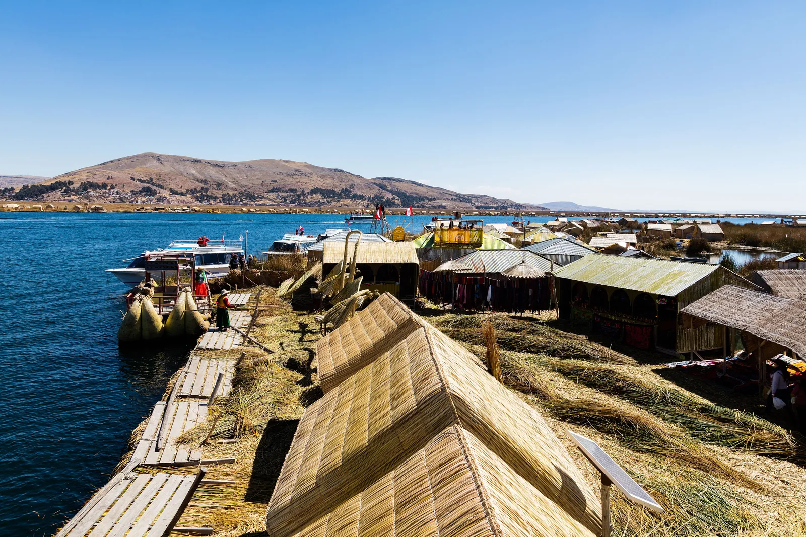
Near Puno, the Uros people live on a cluster of artificial islands built entirely from totora, the tall reed that grows in the lake’s shallows. Layers of cut reed and root mat are piled up and continually renewed from the top as the underside rots away, so an island is in a constant, slow process of being remade. The same reed is woven into houses, boats and even handicrafts.
The Uros tradition of island life is generations old; one account holds that it began as a way to retreat from more powerful neighbours by moving offshore. Today the islands are also a focus of tourism, and a thoughtful visit means recognising that — engaging respectfully with a living community rather than treating it as a spectacle.
Taquile, Amantaní and the weaving islands
Further out on the Peruvian side, the islands of Taquile and Amantaní are solid ground rather than reed, home to Quechua-speaking communities known for their textiles. On Taquile, hand-weaving and knitting are so central to community life and identity that the island’s textile art has been recognised by UNESCO as intangible cultural heritage; men knit and women weave, and the patterns carry meaning.
These islands are quiet, terraced and largely free of vehicles, with footpaths climbing between fields and small settlements. Some travellers stay overnight with local families on Amantaní — a simple, immersive experience and a meaningful source of income for the community.
Isla del Sol and the Inca origin myth
On the Bolivian side, reached from Copacabana, the Isla del Sol — Island of the Sun — holds a central place in Andean cosmology. Inca tradition told that the sun was born here, and that Manco Cápac, the first Inca, emerged from the lake to found the dynasty. The island is scattered with pre-Columbian ruins, terraces and sacred sites, and crossed by old stone paths.
There are no roads on Isla del Sol; you explore on foot, climbing between small communities with the blue lake falling away on every side. The walking is at altitude and the trails undulate, so it asks for steady legs and a measured pace — but the views, and the sense of standing in a foundational landscape of the Andes, are ample reward.
Titicaca on the Andes to Antarctica journey
On Andes to Antarctica, Lake Titicaca is a natural waypoint between the high cities and the salt country, a place where the altiplano shows its gentler, inhabited face after the austere grandeur of the salar and the lagoons. Time on the lake is paced to allow real encounters — with the Uros, the weavers, the sacred island — rather than a hurried circuit.
Because Titicaca sits near 3,800 metres, it also serves the journey’s rhythm of acclimatisation, a comfortable, watery stretch of high country where travellers settle further into the altitude. Our guides work with community-based operators so that a visit supports the people who make these islands extraordinary.
Quick answers
How are the Uros floating islands made?
They are built entirely from totora reeds that grow in the lake’s shallows. Layers of cut reed and reed-root mat are piled up to form a buoyant platform, and the surface is constantly renewed from the top because the underside slowly rots in the water. Houses and boats are made from the same reed.
Why is Lake Titicaca important in Inca tradition?
Andean myth holds the lake as a place of origin: the sun was said to have been born on the Isla del Sol, and Manco Cápac, the first Inca, was said to have emerged from the lake to found the dynasty. The Bolivian Isla del Sol is dotted with pre-Columbian ruins and sacred sites.
How high is Lake Titicaca, and is altitude a concern?
Titicaca lies at about 3,812 metres, so altitude is a genuine consideration — the sun is intense and walking on the islands is felt. Travellers should be acclimatised before visiting, stay hydrated, and take island walks at a steady pace. Within a longer journey, the lake also helps with gradual acclimatisation.
Let the reading become a route.
When an article sparks something, our planners are the next step. Tell us what you are dreaming of.