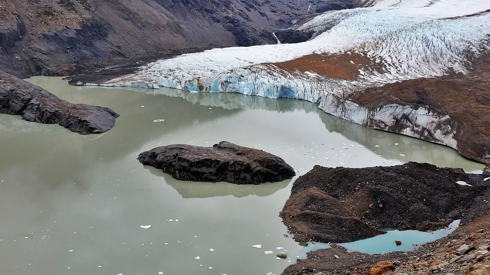
The Carretera Austral: Chile's Road to Nowhere — and Everywhere
Chile's Southern Highway threads nearly 1,300 kilometres through rainforest, glaciers and fjords that have no other land connection to the world — a route so remote and so beautiful that it rewrites a traveller's understanding of the word 'edge'.
There is a road in Chile that ends not because it reaches a city or a border crossing but because the land simply dissolves into ice and ocean. The Carretera Austral — officially Ruta 7 — runs roughly 1,240 kilometres from Puerto Montt in the north to Villa O'Higgins in the south, a thin strip of asphalt and gravel pressed between the Pacific fjords to the west and the Andes to the east, passing through a stretch of South American territory so fractured by glaciers and waterways that large sections have no land connection to the rest of Chile at all. To drive, cycle or navigate it by ferry is to experience the Americas at their most elemental and least mediated.
The road was built in stages between 1976 and 2000 by Pinochet's government, using conscript army labour to push a route through country that cartographers had previously left largely blank. Its construction is contested history — both an engineering achievement of genuine audacity and a project that displaced indigenous communities and flooded valleys for which there was no compensation. What it opened, however inadvertently, was one of the last great land routes on Earth: a passage through temperate rainforest, past hanging glaciers, beneath volcanoes perpetually trailing ash and steam, and beside rivers of a turquoise so saturated they seem digitally enhanced.
The road itself: logistics and the art of moving slowly
The Carretera Austral cannot be driven as a single continuous thread without ferries. The geography of Chilean Patagonia — a coastline so indented by fjords and channels that the land breaks into peninsulas, islands and dead-ends — means that travellers must take vessel crossings at several points, most significantly across the Río Palena and from La Arena to Puelche, and again across the Lago General Carrera to avoid a long overland detour through Argentina. These ferries are not inconveniences but part of the journey itself: low, flat-decked craft loading cars and motorbikes alongside cattle trucks and local schoolchildren, crossing waters that reflect the ice-field mountains behind them with unsettling precision.
The road is mostly gravel south of Cochrane, and roughly corrugated between rains. Speed is not the point. A traveller attempting the full route in a week will see it; one who takes three weeks will begin to understand it. The towns are small and widely spaced — Chaitén, Futaleufú, Coyhaique, Cochrane, Caleta Tortel — and most are equipped with at least one decent hospedaje and a supply of dried goods. South of Cochrane, provisioning becomes genuinely limited, and planning accordingly is not optional.
The north: Chaitén and the volcanoes
The road's northern gateway is Puerto Montt, a functional port city whose main service is to put you on a ferry south to Chaitén or to connect you to the island of Chiloé before crossing back to the mainland. Chaitén itself is haunted in a specifically geological way: in May 2008 the Chaitén volcano erupted for the first time in millennia, burying the lower town in lahar flows and forcing the entire population to evacuate. The new town was built on higher ground; the old town was left as it was found when the waters receded — half-inundated houses, streets still carrying a layer of grey volcanic ash, trees growing through rooftops. It is eerie and oddly beautiful, and it tells you something about the relationship between settlement and landscape along this road.
The country around Palena and Futaleufú — north of where most travellers leave the paved world — is dominated by rivers that have made the region famous among kayakers and white-water rafters. The Río Futaleufú, in particular, is widely regarded as one of the finest technical rafting rivers on Earth, a succession of Class V rapids through a canyon of startling green hills, and it draws an international community of guides and adventurers who have built a modest seasonal economy around the river. For those who do not raft, the river valley is simply beautiful, and the Futaleufú–Argentina crossing offers an optional detour through the Patagonian lake country at the road's most accessible.
The heartland: Coyhaique and the Aysén Region
Coyhaique — the only city on the Carretera Austral, though 'city' here means 50,000 people — is the administrative and supply capital of the Aysén Region, and its oddly pentagonal plaza and unexpected restaurant scene make it feel, after days of small towns, almost metropolitan. It is also the base for two of the route's most rewarding national parks. Parque Nacional Laguna San Rafael, accessible by a long lake ferry south of Puerto Chacabuco, holds the San Rafael Glacier, a wall of blue-white ice calving directly into a saltwater lagoon ringed by the kind of silence that has no urban equivalent. Reserva Nacional Cerro Castillo, south of Coyhaique, offers a multi-day circuit around the castellated basalt towers of Cerro Castillo itself — a trek still quiet enough that you may finish a day without seeing another boot print in the trail.
The Lago General Carrera, which straddles the Chilean-Argentine border south of Coyhaique, is the second-largest lake in South America after Titicaca, and its colour — a milky, glacially ground turquoise — is among the most extraordinary natural phenomena on the road. The Capillas de Mármol, or Marble Caves, on the Chilean side near Puerto Río Tranquilo, are a series of water-sculpted marble formations accessible only by boat: caverns and columns of swirling white, grey and ochre stone that stand in the lake's shallow margins, their reflections doubling their already unreasonable beauty.
The south: Cochrane, Caleta Tortel and the end
South of Cochrane the road enters its final, least-visited and most rewarding stretch. Caleta Tortel, off a short spur road, is a village built entirely on wooden boardwalks above the tidal margins of a fjord — no cars, no streets, only a labyrinth of planks connecting houses, a small church and a couple of simple restaurants perched over the water. It was connected to the main road only in 2003 and retains an isolation that feels genuine rather than performed. The sound of the place — water, birds, the creak of planking — is its defining characteristic.
The road ends at Villa O'Higgins, named for Bernardo O'Higgins, Chile's independence liberator, a settlement of a few hundred people at the edge of the Southern Patagonian Ice Field. The town is the jumping-off point for a crossing into Argentina's El Chaltén via a lake and mountain passage — partly by horse and ferry — that is not for the casually prepared but is one of the great overland routes of the southern hemisphere. To stand at the end of the road here and look south at the ice is to feel, in a way that the phrase does not exhaust, that you have reached the edge of something.
Wildlife and wilderness
The ecological range of the Carretera Austral is extraordinary. The north supports temperate Valdivian rainforest — a dense, moss-laden canopy of coigüe beech, ulmo and mañío trees draped with ferns and bromeliads, dripping with rain for much of the year, home to the pudú (the world's smallest deer) and the elusive huemul, Chile's national animal and one of the most endangered deer on the continent. Rivers carry brown trout and rainbow trout in numbers that make the Aysén region one of the most celebrated fly-fishing destinations in the world, drawing anglers from North America and Europe who have chartered their own small planes to reach lodges accessible no other way.
Sea lions haul out on rocks at the fjord crossings. Andean condors ride the thermals above the river canyons. Black-necked swans and various species of steamer duck inhabit the lakes. In the forests, the chucao tapaculo — a plump, terrestrial bird of the temperate rainforest — announces itself with a loud, liquid call that is one of the defining sounds of the route. The combination of intact habitat and genuine remoteness means that the Carretera Austral offers wildlife encounters of a quality that more-visited regions of Patagonia, for all their fame, can no longer guarantee.
When to go, and how to go
The Carretera Austral is open year-round, but the practical travel season runs from October to April. Summer (December to February) is the warmest and busiest period, with longer days and the highest chance of roads being passable; even so, rain can close gravel sections at any time. October and November bring wildflowers and fewer travellers; March and April bring autumn colour, fewer people still, and the risk of early-season weather. Winter (June to August) is for the specifically committed: roads can be impassable, ferries operate on reduced schedules and some services close entirely.
The choice of transport shapes the experience profoundly. Driving a rental 4WD gives freedom and carrying capacity but requires attention to tyre condition and spare parts. Cycling the Carretera Austral has become a rite of passage for long-distance cyclists, the route's gradient and surface being demanding enough to be serious and manageable enough to be achievable in a summer season; most cyclists travel south to north to take advantage of prevailing winds. Organised expedition journeys that combine vehicle support, guided walks and ferry crossings offer perhaps the most complete way to experience the route without the logistical burden — our guides know the road's rhythms, its hidden viewpoints and the family hospedajes where the food is actually good.
Quick answers
How long does it take to travel the full Carretera Austral?
Driving the full length at a meaningful pace — with stops at the key parks, a ferry crossing at Lago General Carrera and time in Caleta Tortel — requires at least two weeks, and three weeks is more comfortable. Cyclists typically allow six to eight weeks for the full route. The road is long enough and the points of interest numerous enough that rushing it defeats the purpose.
Is the road paved?
The northern section, from Puerto Montt to roughly Coyhaique, is largely paved. South of Coyhaique, and in many northern stretches, the road is unpaved gravel — often well-graded but sometimes corrugated and dusty in dry conditions, or muddy and slow after rain. A 4WD with good ground clearance is strongly recommended; conventional passenger vehicles manage much of the road in good conditions but carry significant risk on the southern sections.
Are ferries mandatory?
Yes, at several points — most notably between La Arena and Puelche (about 30 minutes), and on the crossing of Lago General Carrera via Bahía Murta or Puerto Ibáñez to Chile Chico (several hours). Ferry schedules should be checked and, during peak season, booked ahead. The Naviera Austral company operates most services; Navimag runs a longer passenger-cargo ferry from Puerto Montt south that is itself a journey worth making.
What is the weather like on the Carretera Austral?
Variable and often very wet, particularly in the northern and central sections where the Pacific moisture hits the coastal ranges and produces some of the highest rainfall totals in South America. The Aysén Region receives more than 4,000 millimetres of annual rain in places. The southern end, around Cochrane and Villa O'Higgins, is drier and windier, more typically Patagonian. Waterproof gear is essential throughout the year.
Can I cross into Argentina from the Carretera Austral?
Yes, at several points. The most-used crossings are at Futaleufú in the north, at Chile Chico (crossing to Los Antiguos in Argentina) in the middle, and the wilderness crossing at Villa O'Higgins to El Chaltén in the south. The Villa O'Higgins crossing involves a lake ferry, a guided horse or mountain-bike transfer over a mountain pass and a further lake crossing — it is spectacular and requires advance planning.
Let the reading become a route.
When an article sparks something, our planners are the next step. Tell us what you are dreaming of.