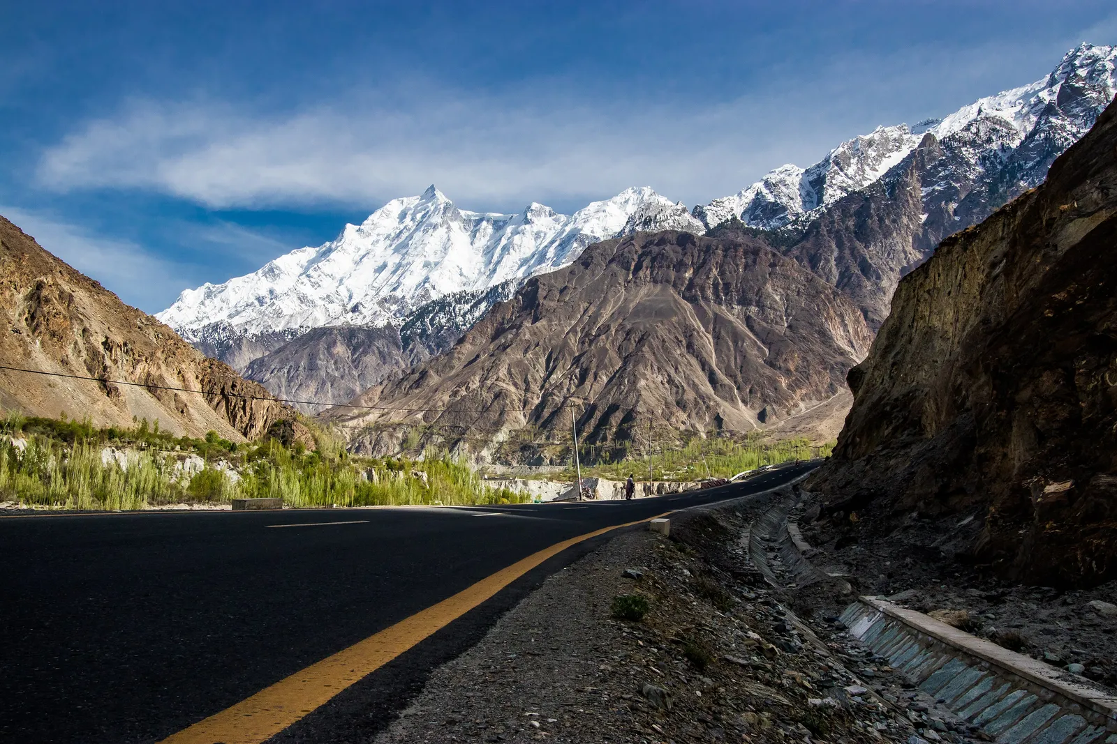
The Karakoram Highway: the Road That Crosses the Roof of the World
The Karakoram Highway threads between the highest mountain ranges on Earth — the Himalayas, the Karakoram and the Hindu Kush — connecting Pakistan to China through the Khunjerab Pass at 4,693 metres. It is the highest paved international border crossing in the world, and the most dramatic road journey in Asia.
The Karakoram Highway did not exist until 1979. Before it, the valley of the Hunza River in what is now Pakistan's Gilgit-Baltistan region was connected to the world by a set of narrow tracks hewn into cliff faces above the gorge, passable on foot and by laden donkey but impassable to vehicles. The highway that replaced these tracks — 1,300 kilometres of paved road running from Hasan Abdal near Islamabad to Kashgar in China's Xinjiang — cost twenty years of construction, vast quantities of Chinese and Pakistani engineering, and the lives of more than 900 workers who died in its building. It is, by any accounting, an act of extraordinary collective will.
The highway follows a path that has carried trade since antiquity — this is one of the strands of the Silk Road's web, the mountain route by which silk, jade, horses and Buddhism all moved between China and the Indian subcontinent. The mountain landscape it passes through is among the most extreme on Earth: three of the world's great ranges meet here, and the Karakoram alone holds more glaciers than any region outside the polar zones. Driving its length is not merely sightseeing but an encounter with scale and geology that recalibrates the traveller's sense of what the natural world is capable of.
Lahore and Islamabad: the threshold
The cultural and historical prologue to any Karakoram journey begins in the Pakistani heartland. Lahore — capital of the Punjab, city of the Mughal emperors — contains some of the finest Mughal architecture outside India: the Lahore Fort, the Badshahi Mosque (one of the largest mosques in the world when completed in 1673), and the Shalimar Gardens, a terraced Mughal pleasure ground of water channels and flowering trees. The walled city's bazaars, where craftsmen produce hand-engraved metalwork and embroidered textiles in the same alleys where their grandfathers worked, are among the most vivid in South Asia.
Rawalpindi and Islamabad — the old cantonment city and the new planned capital that replaced it — are the last major urban centres before the mountains begin. The Lok Virsa Museum in Islamabad provides a useful survey of Pakistan's enormous regional diversity; the Friday Mosque (Faisal Mosque), set against the Margalla Hills, is a striking piece of 20th-century Islamic architecture. From Islamabad, the road turns north and begins to climb: in a matter of hours, the wheat fields of the Punjab give way to the gorges of the Indus, and the traveller understands that the journey has properly begun.
The Indus gorge and the chilas petroglyphs
The first great spectacle of the highway is the Indus gorge itself, where the river has cut through the Himalaya and the Karakoram to create one of the deepest valleys on the planet. The walls are bare rock — the Indus precedes the mountains, and the river has been carving this channel since long before the ranges around it were fully uplifted. At Chilas, where the highway crosses the river, the desert cliffs on both sides are covered in ancient petroglyphs: tens of thousands of incised images of ibex, hunting scenes, Buddhist stupas, bodhisattvas, horses, and the graffiti of Silk Road travellers stretching back over two thousand years.
The Chilas petroglyphs — a UNESCO World Heritage–listed site forming part of the larger Silk Road designation — are one of the most remarkable open-air archives of human movement in Asia. Caravans stopped here for water and shade, and travellers scratched their presence into the rock: prayers, images, records of passage that document the long human conversation between the Indus valley and Central Asia. The Buddhist imagery, particularly, speaks to the period between the 1st and 7th centuries CE when this route was one of the primary vectors by which Buddhist ideas and art travelled from India to China and beyond.
Hunza: the valley of legends
The Hunza Valley, reached after a long day's drive north of Gilgit, is the jewel of the Karakoram Highway and the region whose reputation drew the outside world's attention long before the highway was built. The valley is narrow and intensely cultivated — every available terrace irrigated and planted with apricot, cherry, walnut and mulberry trees — and backed by the stupefying wall of the Karakoram: Rakaposhi (7,788 m), Ultar Sar (7,388 m), Diran (7,266 m) and, to the north, the great glacier-hung bulk of the Batura Mustagh. In April and May, when the fruit trees blossom against the snow, Hunza produces photographs that seem almost too beautiful to be real.
The capital, Karimabad, sits above the valley floor beneath the twin towers of Baltit Fort and Altit Fort — both of Tibetan-influenced construction, built in the distinctive stacked-stone style of the Hindu Kush, commanding views up and down the Hunza River. Baltit Fort, dating in parts to the 8th century and meticulously restored with Aga Khan Trust for Culture support in the 1990s, is among the best-preserved historic fortifications in northern Pakistan. The Hunza people — predominantly Ismaili Muslim, with a history of relative autonomy under their Mir (ruler) until 1974 — are known for their literacy, their longevity and a hospitality that makes the valley one of the most rewarding places in all of Pakistan to slow down and stay.
The Khunjerab Pass and the Chinese border
The road north of Hunza climbs through the Gojal Valley — the upper Hunza, where the language is Wakhi and the landscape empties into a vast plateau of glaciers and brown hills — toward the Khunjerab National Park and the Chinese border. The Khunjerab Pass, at 4,693 metres above sea level, is the highest paved international border crossing in the world: a broad, windswept saddle where a Pakistani flag and a Chinese flag face each other across a few hundred metres of plateau, and where temperatures can drop below freezing in any month of the year.
The national park surrounding the pass is home to the snow leopard, the Marco Polo sheep (Ovis ammon polii, the largest wild sheep in the world, with enormous spiralling horns), the Himalayan ibex and the Tibetan wolf. Sightings of the larger mammals are possible but never certain; the landscape itself — a high-altitude steppe of tawny grass and gleaming glacier — is reward enough. On the Chinese side of the pass, the road descends through the Gez Canyon and Tagharma (Tashkurgan) before reaching Kashgar: three to four hours of increasingly Central Asian landscape that closes the circuit between the Silk Road's mountain routes and its desert oasis cities.
Kashgar: the oasis at the end of the pass
Kashgar sits at the westernmost end of China's Xinjiang region, where the Karakoram Highway meets the roads coming from the Pamirs and the Taklamakan Desert. For centuries it was one of the most important trading junctions on the Silk Road: a place where merchants from China, India, Persia, the steppe and the Mediterranean converged to exchange goods, languages and ideas. The city's Sunday market — still one of the largest in Central Asia — brings Uyghur farmers, traders, herders and craftsmen from the surrounding countryside, and the old lanes around the Id Kah Mosque retain fragments of a mud-brick townscape that speaks directly to the city's trading past.
Kashgar requires the traveller to hold its complexities honestly. The city's Uyghur population has faced severe restrictions under Chinese government policies in recent years, and the old town has been largely demolished and rebuilt in a form that prioritises administrative legibility over historical character. The traveller who comes here in search of an unchanged Silk Road oasis will be disappointed; the traveller who comes in search of the living remnants of a great crossroads culture, and who is willing to look carefully for them, will still find them — in the faces, the food, the music and the extraordinary landscape that surrounds the city on every side.
Practical matters: seasons, visas and the road itself
The Karakoram Highway is open year-round on the Pakistani side as far as Hunza, but the Khunjerab Pass and the crossing into China is seasonal, typically open from May 1 to December 31, and subject to closure for political or weather reasons without much warning. The road itself, despite being paved for most of its length, is a serious mountain highway: landslides block it regularly in summer, winter ice makes it treacherous, and the high altitude of its northern reaches has physiological consequences for travellers who ascend too quickly.
Visitors to Pakistan require a visa, which is now available online for citizens of many countries through the e-visa system, and has become substantially easier to obtain than was historically the case. The Chinese side of the journey requires a standard Chinese tourist visa plus, for independent travellers, specific permissions for Xinjiang that are worth verifying with your embassy before departure. Our itineraries on the Karakoram route include time in Lahore and the Punjab before the mountain drive, time in Hunza for acclimatisation and exploration, and the crossing into Kashgar for the full Silk Road circuit.
Quick answers
How long does it take to drive the full Karakoram Highway?
The full highway from Hasan Abdal (near Islamabad) to Kashgar is approximately 1,300 kilometres and takes a minimum of four to five days of driving if driven without stops — which no one should do. A meaningful journey that includes Lahore, the Indus gorge, Chilas, Gilgit and several days in Hunza before crossing into China typically takes two to three weeks. Most travellers choose to drive the Pakistani section and then fly from Islamabad to Kashgar, or do the route in one direction only.
Is it safe to travel in northern Pakistan?
Gilgit-Baltistan, the northern mountain region through which the highway passes, has a significantly different security profile from other parts of Pakistan that have experienced instability. The region is generally considered safe for travellers and receives considerable Pakistani and international tourism. The Hunza Valley in particular has a well-developed hospitality infrastructure and a long tradition of welcoming visitors. As always, check current government travel advisories before departure and work with a specialist operator who monitors local conditions.
What should I know about the altitude on the Karakoram Highway?
The highway reaches 4,693 metres at the Khunjerab Pass, and the Hunza Valley itself sits between 2,400 and 3,000 metres. Altitude sickness is a genuine risk if ascent is rapid; the standard mitigation is to spend at least one to two nights in Gilgit (1,500 m) before continuing to Hunza, and to ascend to the pass on a day trip from Hunza rather than sleeping at altitude. Drink plenty of water, avoid alcohol at altitude, and do not ascend if you have symptoms of AMS.
Is the Khunjerab Pass open year-round?
No. The Khunjerab Pass and the border crossing to China is officially open from 1 May to 31 December, but the actual dates vary by year and can be affected by weather, diplomatic considerations or infrastructure maintenance. The pass can also close at short notice due to landslides or heavy snowfall. The Pakistani highway south of the border, down to Hunza and Gilgit, is generally accessible year-round, though winter conditions between November and March require care.
What is the best time of year to travel the Karakoram Highway?
Late April to early June is one of the most beautiful periods in Hunza, when the fruit orchards bloom against the snow-covered peaks — the combination of blossom and mountain is among the great landscape spectacles of Asia. July and August are warm, clear and the easiest for driving but the busiest. September and October offer excellent mountain visibility and the harvest season in the valleys. Winter closes the pass and brings heavy snow above Gilgit, but the lower valleys remain accessible and remarkably atmospheric.
Let the reading become a route.
When an article sparks something, our planners are the next step. Tell us what you are dreaming of.