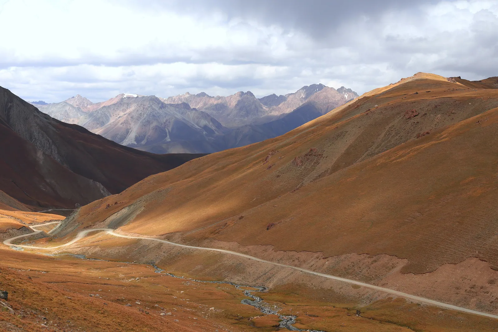
The Pamir Highway: Roof of the World
The M41 crosses Tajikistan at an average altitude above 4,000 metres — the world's second-highest road, threading a plateau of glaciers, yak herders and abandoned Soviet outposts through the heart of the Pamir mountains.
The Pamir Highway is one of the great overland routes of the world, and it earns that status through sheer, sustained altitude. The M41 — to use its Soviet designation, still the most common name for the road — runs from Dushanbe, the Tajik capital, across the high Pamir plateau to the Chinese border at the Kulma Pass, a distance of roughly 1,200 kilometres of which a significant portion sits above 4,000 metres. It is the world's second-highest road after the roads of the Tibetan plateau, and it crosses a corner of the Earth so sparsely inhabited that the villages it passes are sometimes separated by a hundred empty kilometres of rock, glacier and sky.
The Pamirs themselves — the Great Pamir, the Little Pamir, the Wakhan Corridor pressed between the Hindu Kush and the range's southern spurs — were a Silk Road crossing almost too hard for regular caravans. The route existed because it had to: the southern branch of the road, threading Afghanistan and the Wakhan, was the only practical way through this part of Central Asia. Today the highway follows its rough alignment, and driving it is an experience that has changed less than almost any other journey of this length on Earth.
The road and what built it
The Pamir Highway's modern form is a Soviet creation. The road was engineered and paved — loosely, in places — by the USSR during the 1930s to consolidate its grip on a strategically exposed frontier. Before the highway, the only movement across the high plateau was by foot, horse or yak, as it had been for the Silk Road caravans threading the mountain passes. The Soviets built a road both to administer the region and to position military assets; the string of garrison towns and weather stations they planted at intervals across the plateau can still be read in the settlements the highway passes through.
Since Tajik independence in 1991 the road has been only intermittently maintained, which is part of its character. Stretches that are surfaced alternately with stretches of washboard gravel or sections where the road simply ends at a riverbank and resumes on the other side. Crossing a high pass in a shared jeep with a driver who has made the journey dozens of times, understanding every rut and drift, is an experience that most vehicle-based journeys in the world cannot reproduce.
The Wakhan Corridor
The southern spur of the Pamir Highway dips into the Wakhan Corridor, the narrow panhandle of Afghan territory that separates Tajikistan from Pakistan and reaches east to touch China. The Wakhan was among the most important sections of the southern Silk Road: Marco Polo crossed it in the 13th century and described the Great Pamir plateau in terms that match the landscape almost exactly today — wide, cold, windswept and grazed by enormous herds of the wild sheep that carry his name, the Marco Polo sheep.
Travelling the Tajik side of the Wakhan — the Ishkashim district — a traveller faces Afghanistan across a river measured in tens of metres. Afghan villages are clearly visible on the far bank, and on market days Afghans and Tajiks cross to trade. The geopolitical situation has kept this crossing closed to most visitors for years, but the Tajik Wakhan is accessible and extraordinary: a deep valley of ancient Buddhist settlements, abandoned caravanserais and the Yamchun fortress, a Silk Road-era citadel perched on a ridge three thousand metres above sea level with views toward the Hindu Kush.
The high plateau and its people
Above the Wakhan the highway climbs onto the Pamir plateau proper — the Murghab district, a broad, almost flat highland grazed by Kyrgyz herders who stayed here after the region's political lines were redrawn in the Soviet period. Murghab town, at 3,600 metres, is the highest administrative centre in Tajikistan and the only real settlement on the plateau; its market is the supply point for communities scattered across an area the size of Switzerland.
The Kyrgyz families of the plateau live in yurts and small stone houses, herding yaks and sheep between seasonal pastures as they have for centuries. The plateau is extraordinarily bare — treeless, in places almost vegetationless, the mountains folded and brown around a flat horizon broken by lakes of impossible blue — and its people have the contained, self-sufficient quality of those who understand that the nearest help is very far away. A traveller who spends a night in a family homestay on the plateau will remember it alongside the landscape itself.
Lakes and glaciers: the plateau's water
The Pamirs are the headwaters of some of Asia's most important rivers. The Panj, which forms much of the Tajik-Afghan border, gathers from glaciers on the plateau and runs southwest to join the Amu Darya, the ancient Oxus that fed the oasis cities of Uzbekistan. The Bartang, flowing north and west through some of the deepest gorges on Earth, drains the same glacial field in the opposite direction.
The plateau's lakes are among the most striking features of the journey. Lake Karakul, at 3,914 metres, sits in a meteorite crater and is one of the highest lakes of significant size in the world; its water is a deep mineral blue, its shores bare gravel and occasional yurt, the surrounding peaks carrying glaciers that calve directly into it. Zorkul, farther east on the Afghan border, is the lake Marco Polo described — high, reedy, wild — and the place where the great Silk Road traveller estimated himself to be at the roof of the world.
Preparing for the journey
The Pamir Highway demands respect for its altitude. The plateau sits consistently above 3,500 metres, with passes reaching over 4,600 metres, and altitude sickness is a genuine risk for travellers moving quickly from lower elevations. A cautious approach — spending a day or two in Dushanbe or the mid-altitude Gorno-Badakhshan towns before ascending — makes a significant difference. The journey is typically done by shared jeep or 4WD, arranged in Dushanbe or Khorog, over four to seven days depending on how many detours are included.
Accommodation along the route ranges from basic guesthouses in Khorog and Murghab to community homestays in between, many run through established networks that ensure the income reaches the host families directly. A GBAO permit — issued at the Tajik border or in Dushanbe — is required for the Gorno-Badakhshan region through which most of the highway runs. The road is open from approximately May to October; outside that window, the high passes close under snow and the journey becomes impossible.
The Silk Road connection
The caravans that crossed the Pamir carried the southernmost branch of the Silk Road. This was not the route for light, fast couriers but for the slow, substantial trade in bulky goods — lapis lazuli from the mines of Badakhshan, rubies from the Panj tributaries, horses and furs moving west, and Chinese goods moving east. The Pamir was also the conduit for Buddhism's passage from India into the Tarim Basin oases, and the region's rock carvings and ruined stupas record that older, religious traffic as clearly as any text.
For the traveller who has moved through Uzbekistan's polished Timurid cities and the relatively accessible Tian Shan, the Pamir offers a different encounter with the Silk Road's logic: not the sophisticated urban end of the network, but its most demanding middle section, the place where the route asked everything of those who used it. The landscape has changed less here than anywhere else on the road, and that is precisely its value.
Quick answers
What is the Pamir Highway?
The Pamir Highway, officially the M41, is a road that crosses the Pamirs of Tajikistan from the capital Dushanbe to the Chinese border, roughly 1,200 kilometres in length. It is the world's second-highest road after the roads of the Tibetan plateau, with much of its route above 3,500 metres and passes exceeding 4,600 metres. It follows the approximate alignment of the southern branch of the Silk Road.
Is the Pamir Highway safe to travel?
The highway is regularly travelled by independent travellers and is not considered especially dangerous for those who prepare properly. The main risks are altitude sickness, road conditions that require a capable vehicle and experienced driver, remote location limiting emergency assistance, and weather that can close passes rapidly. Travelling with an experienced local driver and acclimatising carefully are the two most important precautions.
What is the Wakhan Corridor, and can travellers visit it?
The Wakhan Corridor is a narrow strip of Afghan territory between Tajikistan and Pakistan, historically one of the most important sections of the southern Silk Road. Marco Polo crossed it in the 13th century. The Tajik side of the Wakhan — the Ishkashim and Wakhan districts — is accessible to travellers with the appropriate GBAO permit, and contains ancient fortresses, Buddhist ruins and extraordinary mountain scenery.
What permit is needed to travel the Pamir Highway?
Travellers need a GBAO permit (Gorno-Badakhshan Autonomous Oblast permit) for the eastern portion of the highway. This is obtained at the Tajik border or through a registered agency in Dushanbe, and is a straightforward process. A standard Tajikistan tourist visa is also required. Those planning to enter the Wakhan Corridor should confirm current requirements with a reliable local operator before travelling.
Let the reading become a route.
When an article sparks something, our planners are the next step. Tell us what you are dreaming of.