The Quebrada de Humahuaca: Argentina's Painted Gorge
A UNESCO World Heritage canyon in Argentina's far northwest, the Quebrada de Humahuaca is ten thousand years of Andean civilisation painted in ochre, burgundy and violet across mountains that defy a photographer's colour calibration.
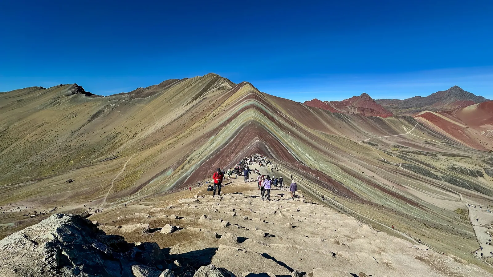
There is a sequence in the Quebrada de Humahuaca, when the light is low in the late afternoon, that recurs with the reliability of a natural law: the mountains turn from the warm, dusty browns of midday into something that has no name in the standard geological palette — deep burgundy above, transitioning through orange and ochre to buff and violet, with the Rio Grande threading its silver line through the canyon floor and the white bell towers of a colonial village catching the last horizontal light. The image looks processed, artificially saturated, which is why every photographer who arrives here eventually stops adjusting the colour balance and simply accepts what the world has made.
The Quebrada de Humahuaca — 'quebrada' meaning ravine or gorge — runs for roughly 155 kilometres through the Jujuy Province of northwestern Argentina, from just north of the provincial capital of San Salvador de Jujuy at around 1,200 metres up to the Bolivian border at La Quiaca at more than 3,400 metres. In 2003 it was inscribed on the UNESCO World Heritage List, recognised for the overlapping layers of its significance: it has been a route of human passage between the Andean highlands and the subtropical lowlands for at least ten thousand years, has supported successive pre-Columbian cultures, served as the road by which Spanish colonial expansion moved north, and carries in its towns and villages a living indigenous Andean culture of considerable depth and resilience.
The geology: why the mountains are this colour
The colours of the Quebrada's walls are not a tourist invention. They are the result of sedimentary rock formations laid down across different geological epochs, each with a distinct mineral composition that weathers to a different colour in the dry, high-altitude air. The most famous section is the Serranía de Hornocal, visible from the village of Humahuaca, where the Cerro de los 14 Colores — the Hill of Fourteen Colours — presents a folded ridge of extraordinary multicoloured strata: red from iron oxides, white and grey from limestone and marine sediments, purple and violet from manganese compounds, green from volcanic tuffs, yellow and ochre from limonite. The ridge has been tilted nearly vertical by the Andean uplift, so the layers that would normally lie horizontal have been thrust skyward, presenting their cross-section like a geological sample to the traveller looking up from the valley.
The overall palette of the canyon walls changes throughout the day with the angle of the light. At dawn, when low raking light hits the cliffs from the east, warm reds and oranges dominate. By midday, under direct overhead sun, the colours bleach toward sand and buff. In the hour before sunset, the long shadows bring out the deep purples and burgundies that are the distinctive signature of the Quebrada. The light in the gorge is a subject of study in itself, and the practical consequence for visitors is clear: arrive by noon to orientate, and hold your afternoon free.
The ancient road: Inca and pre-Inca
The Quebrada was never simply a beautiful canyon. It was the road — the principal route connecting the Andean altiplano with the valleys and subtropical forests to the south and east, used by successive cultures over thousands of years. The Omaguaca people, who gave the quebrada its name, were among the pre-Inca cultures that occupied the canyon before the Inca expansion in the late fifteenth century brought the region into Tawantinsuyu. The Inca built one of their principal roads, the Qhapaq Ñan, through the quebrada, establishing tambos (way stations) and controlling the movement of goods, people and armies along this strategic corridor. Sections of the Inca road are still visible and walkable, pressed into the cliff faces in the classic Inca stone-and-earth construction.
The pukará — fortified hilltop settlements — are the most visible legacy of the pre-Columbian cultures of the quebrada. The Pucará de Tilcara, just north of the village of Tilcara, is the best-preserved of these: a hilltop complex of stone enclosures, ceremonial spaces and storage rooms, partially reconstructed in the early twentieth century by archaeologists from the University of Buenos Aires. From its summit, the view down both reaches of the canyon — north and south, with the river threading through the floor below — is one of the great panoramic views of northwestern Argentina, and the context of occupation makes it more than merely scenic.
The towns: Humahuaca, Tilcara and Purmamarca
The three principal towns of the quebrada each have a distinct character that rewards time over simple passage. Humahuaca, the administrative centre and the one that gives the gorge its name, is a colonial town of adobe and whitewash at 2,939 metres, its main square dominated by the church of La Candelaria and the famous monument to the Independence Heroes — a bronze figure that emerges from a clock tower at noon each day to a burst of music. The town's market is the most serious in the quebrada, with weavers and craftspeople from the surrounding communities selling textiles of distinctive regional design, and the music of the Carnaval — one of the most extraordinary indigenous celebrations in Argentina — resonates through the calendar from January.
Tilcara is smaller and more traveller-oriented, with a cluster of excellent restaurants, a botanical garden of Andean medicinal plants, and the Pucará within walking distance. It has become the cultural capital of the quebrada in recent years, home to artists and musicians drawn by the light and by the indigenous textile and music traditions of the surrounding communities. Purmamarca, the southern gateway and the village most easily reached from Jujuy, sits below the most dramatically coloured of the quebrada's hills — the Cerro de los Siete Colores, the Hill of Seven Colours — and its handicraft market in the central square is one of the most concentrated collections of regional artisanship in Argentina. Staying the night in Purmamarca allows the evening light on the hill to be seen from the village square, which is the experience at its most immediate.
The people: indigenous culture and the living calendar
The quebrada is not a landscape museum. It is home to a living indigenous Andean population — primarily Kolla and descendants of the Omaguaca — whose cultural practices, relationship to the land and ritual calendar constitute a continuity stretching back long before the Spanish arrival. The textiles woven in the quebrada's communities use natural dyes extracted from local plants and minerals, and patterns that encode information about community identity, kinship and cosmology in ways that have been passed from woman to woman across generations. The weaving cooperatives of Tilcara and Humahuaca are not tourist operations but active communities of practice.
The Carnaval of the Quebrada de Humahuaca is one of the most genuinely distinct Carnival traditions in South America. Running for two weeks in January and February, it is centred on the figure of the Pujllay, a spirit of music and disorder who is ritually buried at the carnival's end. The celebration involves days of dancing, music (the erke, siku and charango are the defining instruments), eating and drinking, with communities moving between villages in processions that occupy the valley floor. It is not a performance for visitors but a community observance — and all the more extraordinary for that.
The altiplano beyond: Salinas Grandes and the puna
The Quebrada de Humahuaca is the corridor to the puna — the high Andean plateau of northwestern Argentina, a landscape of salt flats, volcanoes and altiplano grassland that extends north and west toward Bolivia and Chile. The Salinas Grandes, accessible by a spectacular road that climbs from Purmamarca over the Sierra de Muñano at more than 4,000 metres, is a salt flat of 212 square kilometres at 3,450 metres elevation — a smaller but no less extraordinary version of the Bolivian Uyuni, its hexagonal crusts forming a white plain broken only by the distant silhouettes of Andean peaks.
The road from Purmamarca to the Salinas Grandes is itself one of the finest drives in the region: the Cuesta de Lipán climbs through a series of hairpin bends past a succession of geological formations — the rock changes colour with almost every curve — before topping out on the altiplano plateau and revealing the salt flat's white surface below. From the Salinas Grandes, the road continues to Susques and to the crossing into Chile at the Paso de Jama — one of the high-altitude routes to the Atacama Desert — making the quebrada a natural connector between the Argentine northwest and the Chilean altiplano.
Practical matters: when to visit and how to travel
The Quebrada de Humahuaca is accessible year-round, but the most comfortable conditions fall in the dry season from April to November. Summer (December to March) is the rainy season on the altiplano, with afternoon thunderstorms common — the rain brings the rarest colours out of the rock and the valley floor greens dramatically, but roads can be affected and some higher passes may close temporarily. January and February also coincide with Carnaval, which is either the best reason to visit or a consideration for those who prefer quiet.
The most natural way to travel the quebrada is by renting a car in Jujuy or Salta and driving north, staying a night each in Purmamarca, Tilcara and Humahuaca. The main road is paved and well-maintained; the roads to the Salinas Grandes and to higher villages are gravel and benefit from a high-clearance vehicle. The train that once ran the full length of the quebrada to Bolivia — the 'Tren a las Nubes' out of Salta takes a parallel branch rather than the quebrada itself — no longer operates regularly as a passenger service, but day excursions are available on the Cloud Train route, an extraordinary piece of engineering that crosses viaducts and spirals and reaches 4,220 metres.
Quick answers
What is the best time of day to see the colours of the Quebrada?
Late afternoon — from about two hours before sunset — is when the low-angled light brings out the deepest reds, purples and ochres of the canyon walls. Dawn is also excellent, particularly on the eastern-facing cliffs. Midday light is the least interesting for photography, as the overhead sun bleaches the colours toward buff and sand. If you are staying in Purmamarca or Tilcara, arranging your days to be free in the late afternoon specifically for walking or driving to a viewpoint is the single most important logistical decision.
How long should I allow for the Quebrada?
Two to three full days is the minimum to give each of the main towns — Purmamarca, Tilcara and Humahuaca — adequate time, plus a half-day excursion to the Pucará de Tilcara and a trip to the Serranía de Hornocal or the Salinas Grandes. Five days allows for the Salinas Grandes excursion, a drive to some of the smaller villages, and the kind of unhurried afternoon sitting that the light demands. The quebrada rewards slow travel more than almost any landscape in Argentina.
What is the altitude, and should I be concerned?
The quebrada climbs from around 1,200 metres at Jujuy to 2,939 metres at Humahuaca. The towns themselves are generally at altitudes where healthy travellers will feel fine after a brief period of adjustment; the main concern is the excursion to the Salinas Grandes, which crosses 4,000 metres on the Cuesta de Lipán. Allowing a day to acclimatise in Tilcara or Purmamarca before ascending to the altiplano, drinking plenty of water and avoiding alcohol on the first day are the standard precautions. Ascending rapidly from Jujuy directly to the altiplano is not recommended.
Can I combine the Quebrada de Humahuaca with a visit to Bolivia?
Yes, easily. The town of La Quiaca at the northern end of the quebrada has a pedestrian bridge crossing to the Bolivian town of Villazón, from where buses run to Uyuni, Potosí and Sucre. The crossing is straightforward for most nationalities. The Paso de Jama, accessible from the Salinas Grandes road, crosses into the Chilean Atacama — a spectacular high-altitude route that requires a reliable vehicle but opens the possibility of combining the quebrada with a drive north through the Atacama.
What are the best things to buy in the quebrada's markets?
Woven textiles — ponchos, mantas (blankets) and bolsas (woven bags) — in the regional palettes of natural browns, reds and blues are the most distinctive and authentic purchase. Look for natural-dye pieces, which have a warmth and subtlety that synthetic-dye versions lack; sellers in Tilcara and Humahuaca can explain the dyeing process. Ceramic figures in the local style, silver jewellery in Andean designs, and dried herbs from the puna (among them maize for chicha and medicinal plants) are also characteristic.
Let the reading become a route.
When an article sparks something, our planners are the next step. Tell us what you are dreaming of.